What’s Different in the Legislative Redistricting Advisory Commission’s Proposed Congressional Map for the ‘Big Eight’?
When lawmakers convene in special session to tackle congressional redistricting Monday, two proposals will be on the table — though one is at a clear advantage.
That map is from the Legislative Redistricting Advisory Commission, a panel convened by Senate President Bill Ferguson (D-Baltimore City) and House Speaker Adrienne A. Jones (D-Baltimore County). Members of the commission include Jones and Ferguson, alongside two other Democratic legislative leaders and two Republican legislative leaders.
The other congressional redistricting proposal is from the Maryland Citizens Redistricting Commission, created by Gov. Lawrence J. Hogan Jr. (R). That commission included three Republicans, three Democrats and three unaffiliated voters. Hogan has said he would veto any congressional redistricting plan that varies from the one proposed by his Maryland Citizens Redistricting Commission — but Democrats hold a veto-proof majority in both the House of Delegates and the state Senate, and have easily overridden dozens of measures during the governor’s tenure.
That means the Legislative Redistricting Advisory Commission’s congressional proposal is the most likely to be enacted by lawmakers during next week’s special session. The map includes some consequential changes to congressional districts in Maryland’s eight largest jurisdictions, although Aro said at a November meeting that the commission aimed to keep “as many people as possible in their current districts for continuity reasons.”
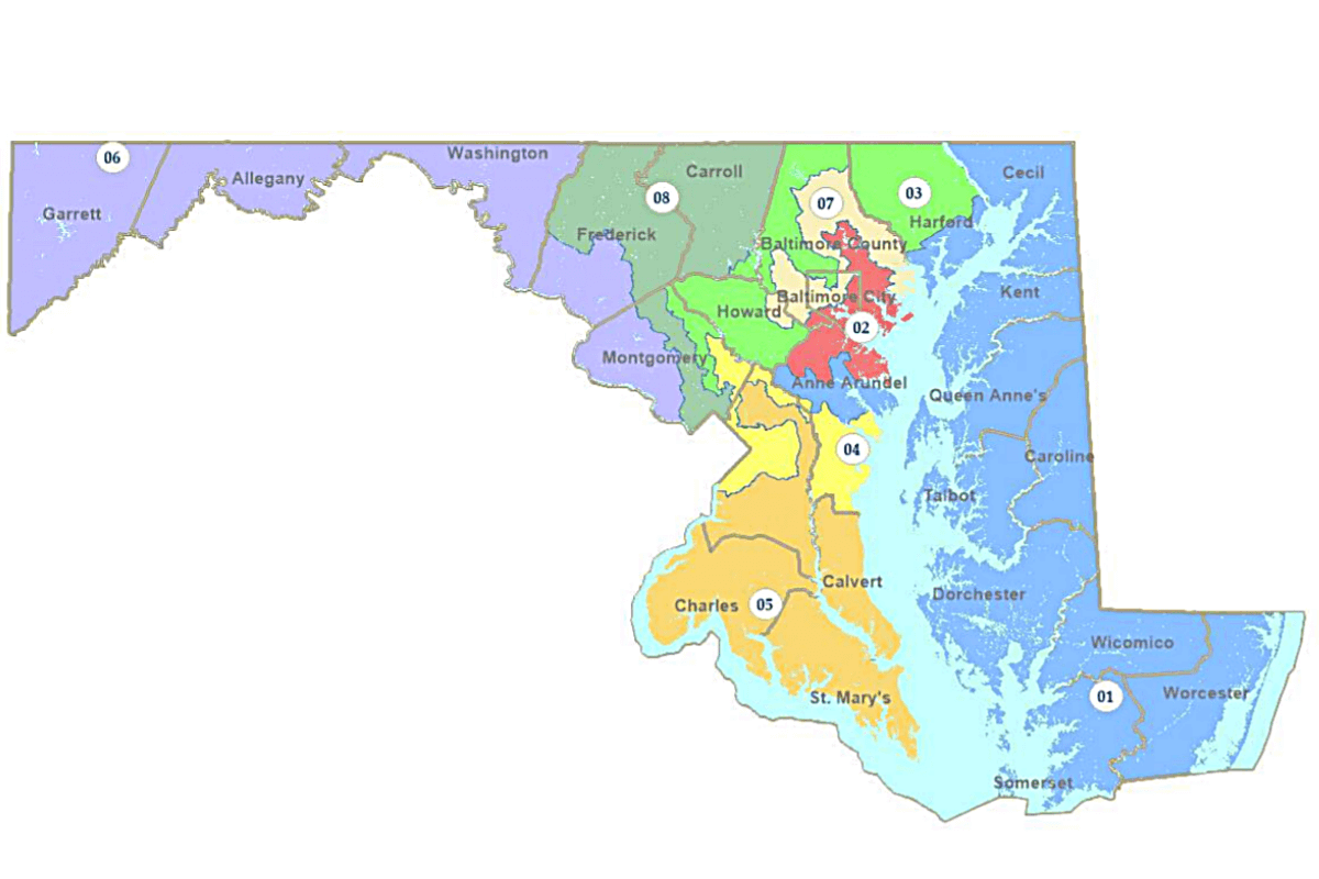
Here’s a look at how the Legislative Redistricting Advisory Commission’s congressional redistricting proposal affects the state’s eight largest jurisdictions. While this article includes descriptions of the congressional districts and images of both current districts and those proposed by the Legislative Redistricting Advisory Commission (LRAC), residents can find out their exact congressional district in the proposed map via this online tool. That website also includes an interactive version of the proposed map.
An interactive map of current congressional districts is also available online.
Anne Arundel County
Anne Arundel County is currently split between four congressional districts. The 2nd District includes the far northwestern portions of the county and Fort Meade; the 3rd District snakes from Annapolis up the coast before looping west through Glen Burnie and south of Fort Meade out of the county; the 4th District includes most of the central portion of the county and exits in a narrow line to the west; and the 5th District includes most of the southern and eastern portions of the county.
In the proposed map, the county would contain three congressional districts. The 1st District would cross at the Chesapeake Bay Bridge and split the middle of the county; the 4th District would include the entire southern portion of the county instead of the 5th District; and the 2nd District would include Fort Meade and the northern portion of the county.
The county is part of one of the most consequential shifts in the LRAC proposal: the 1st District, which is currently home to the state’s lone congressional Republican, Rep. Andrew P. Harris, would lean Democratic after the middle portion of the county is added to the district that also includes the Eastern Shore, creating the potential of an all-Democratic congressional delegation.


Baltimore City
Baltimore is split between three districts in current maps: The 2nd, 3rd and 7th.
Under the Legislative Redistricting Advisory Commission proposal, the 2nd District would include most of the southern and eastern borders of the city. The 7th District would include most of the west, central and much of the northeast portion of the city. The 3rd District would include Baltimore’s northwest border and dips down from the north along Interstate 83.


Baltimore County
Under current maps, Baltimore County is split between four congressional districts: the 1st, 2nd, 3rd and 7th. The 1st District stretches across the far northern portion of the county, connecting eastern parts of Carroll County to Harford County before continuing down the the entire Eastern Shore.
In maps proposed by the LRAC, Baltimore County is split between three congressional districts: the 2nd, 3rd and 7th.


Frederick County
Frederick County is currently split between two congressional districts: The 6th District stretches from Western Maryland, moves along the far southern part of the county and then loops up to capture the city of Frederick. The rest of the county is included in the 8th District.
The LRAC congressional map keeps a similar configuration, although the 6th District includes more of the southern half of the county, bumping only slightly north to include the city of Frederick. The rest of the county is still included in the 8th District.


Harford County
The southern portion of Harford County along the Chesapeake Bay is included in the 2nd District in current maps, with the 1st District moving north through the remaining portion of the county before it enters Baltimore County.
Under the proposed LRAC map, the county’s congressional map would look geographically similar, albeit with different districts: The 1st District would follow along the coast, and the 3rd District would include the remainder of the county.


Howard County
Howard County is currently split between three congressional districts. The 2nd District includes most of the far southeastern portion of the county around Jessup; the 3rd District enters the county in the southeast from Anne Arundel and Montgomery counties and moves narrowly northwest to enter Baltimore County; and the 7th District includes the remainder of the county.
Under the proposed LRAC map, the 3rd District would include all of the county except for an area surrounding Ellicott City, which would be in the 7th District.


Montgomery County
Montgomery County is currently split between three congressional districts: the 3rd, 6th, and 8th.
Under the proposed LRAC map, Montgomery County would be split between four congressional districts. The 6th District boundary would stretch further south of Potomac and include more of the Rockville area. The 8th District would still include the county’s border with Washington D.C. and run from north to south in the central part of the county. The 3rd District would include the northern half of Montgomery County’s border with Howard County and roughly follow Georgia Avenue south before ending north of Wheaton. The 4th District would extend west from Prince George’s County to include areas around the southern half of Montgomery County’s border with Howard County.


Prince George’s County
Prince George’s County is kept largely the same in the LRAC proposal compared with current maps. In both configurations, the 5th District includes portions of southern Prince George’s County with southern Maryland and curves north along the border with Anne Arundel County.
The proposed 5th District then moves west to include the area around College Park, although that district would no longer include portions of Anne Arundel County. The remaining central portion of the county would include the 4th District, which in the proposed LRAC maps briefly exits into Montgomery County near the border with Washington D.C. before looping back to include the northern portion of Prince George’s County and then continuing east into Anne Arundel County.


Hearing Monday
The proposed LRAC map would create eight congressional districts that favor Democrats, according to a Princeton Gerrymandering Project analysis that gave the LRAC redistricting plan an overall “F.”
Analysts at Princeton evaluated the map based on competitiveness, partisan fairness and geographic features.
The Maryland Citizens Redistricting Commission map, drafted by a multi-partisan commission formed by Gov. Lawrence J. Hogan Jr. (R), received an overall “A” from the Princeton Gerrymandering Project. That map would create a 6-2 partisan breakdown, with the 6th District and the 1st District favoring Republicans.
A joint legislative hearing on the proposals will be held Monday at 12:30 p.m.
Bennett Leckrone
Reporter
Bennett Leckrone was a Report for America corps member at Maryland Matters through May 2022. He is a December 2019 graduate of the E.W. Scripps School of Journalism at Ohio University. Leckrone has interned at The Chronicle of Higher Education, The Columbus Dispatch, PennLive.com, The Dayton Daily News and The Troy Daily News.
Related Articles

Unpublicized City Council vote picks Baltimore company to be the casino operator in Petersburg, south of Richmond along Interstate 95.

“We need to stop allowing our worst instincts to drive the conversation,” said House Speaker Adrienne A. Jones (D-Baltimore County).

When there’s a crisis such as the collapse of the Key Bridge and other major events, food support networks such as the Maryland Food Bank try to stay ready to help.
 Creative Commons Attribution