The Major Shakeups for Incumbents in Legislative Leaders’ Redrawn Congressional Map
The new congressional map advancing through the General Assembly this week, after a judge ordered the boundaries to be redrawn, includes the biggest shakeups to Democratic incumbents’ district lines in recent memory.
The new map — redrawn over the weekend after a judge, on Friday, tossed out one the General Assembly had approved in December — quickly advanced through the Senate on Tuesday amid Republican objections.
Republicans argue that the newest map, which includes a solidly Republican 1st District and a much more competitive 6th District, still isn’t compact enough to comply with Senior Judge Lynne A. Battaglia’s order.
The redrawn map includes several shifts that could have an impact on the 2022 elections.
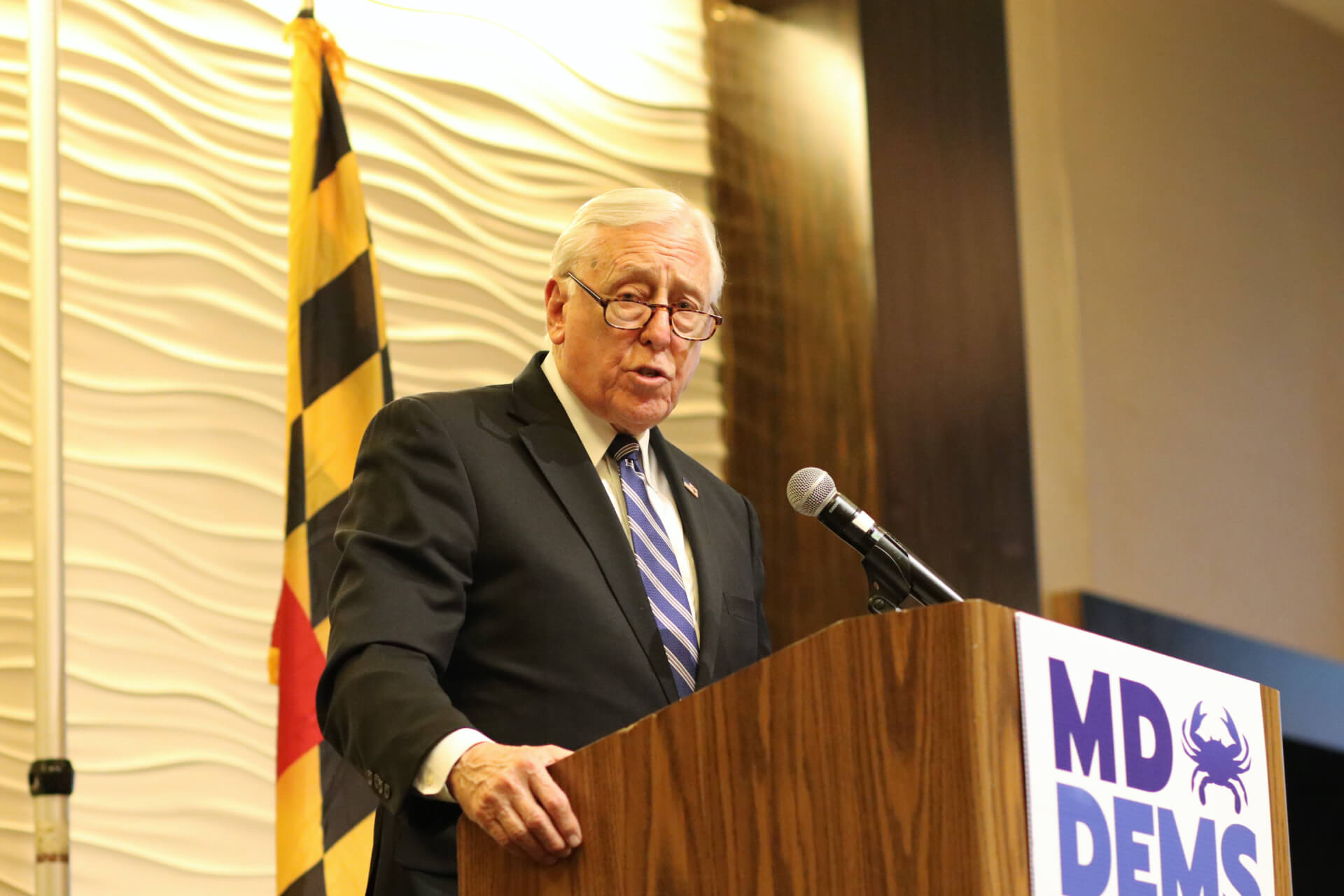
One of the notable changes is to Democratic House Majority Leader Steny H. Hoyer’s 5th District, which would no longer include College Park. That district had long been tailored for Hoyer, looping north and hooking around central Prince George’s County from Southern Maryland to include College Park. Under the latest map, District 5 encompasses a large portion of southern Anne Arundel County and moves north to include Fort Meade rather than turning west toward Washington, D.C.
Hoyer, who was president of the state Senate before being elected to the U.S. House of Representatives in a special election in 1981, worked with his successor — Senate President Thomas V. “Mike” Miller Jr. (D) — to craft the 5th District into its longstanding shape. Including College Park with Southern Maryland had become a staple of Hoyer’s district.
Rep. C.A. Dutch Ruppersberger’s 2nd District would dramatically change. In the state’s 2011 congressional redistricting plan, the district ran narrowly from Fort Meade through Baltimore and into Harford County, and also snaked around Baltimore County’s border with Baltimore City. Now District 2 would include most of Carroll County and most of Baltimore County, except a strip along the Harford County line and areas just west of Baltimore. It would also include parts of northern Baltimore. That change could mean a higher proportion of Republican voters in the district.
A spokesperson for Ruppersberger, who has represented the 2nd District since 2003, said the congressman didn’t have input on the new map.
“We are still reviewing the map and look forward to seeing this process completed through the state legislature and the court,” Jaime Lennon, the spokesperson, said in an email.
The 3rd District previously provided fuel for any potential future statewide run for Rep. John P. Sarbanes (D), snaking (in the 2011 map) from Annapolis around to Burtonsville and Olney in Montgomery County, narrowly moving through Baltimore City and including areas of Baltimore County. That district would have been made slightly more compact in the December plan but is significantly more compact in the latest map. Sarbanes’ district would now include northern Anne Arundel and all of Howard counties and parts of Carroll County.
Changes to the 6th District would appear to make it more competitive for Republicans. District 6 would include less of Montgomery County but all of Frederick County and Western Maryland, potentially making Rep. David Trone (D) less secure in future elections. It also would shift away from Trone’s home in Potomac, ending just south of Gaithersburg, rather than extending south toward the D.C. border as did the map enacted in December.
Meanwhile, the 8th District would become even more solidly Democratic. In the 2011 map, the district looped north from Montgomery County to include rural areas of Carroll and northern Frederick counties. It would now be contained entirely within southern Montgomery County, virtually ensuring a Democratic victory in future elections. That district is currently represented by Rep. Jamie B. Raskin (D).
Another District that would help an incumbent is the newly drawn 1st District, represented by Maryland’s lone congressional Republican, U.S. Rep. Andrew P. Harris, who handily won reelection under the 2011 district map, which included portions of Harford, Baltimore and Carroll counties with the Eastern Shore.
District 1 was set to become much more competitive for Democrats in the December proposal, crossing the Chesapeake Bay to include parts of Anne Arundel County with the Eastern Shore. Under the latest map it would include all of Harford County instead to be a solidly Republican district. As in the state’s initial map, Harris’ home in Cockeysville would not be within District 1 in the latest map, though he will still be able to run there: The U.S. Constitution requires lawmakers to live in the same state but not necessarily in the district they seek to represent.
The 7th District would shift away from its previous boundaries, originally drawn to comply with the federal Voting Rights Act, and would remain largely within Baltimore City rather than branching further west and north into Baltimore County. The district would include some areas immediately west of Baltimore, like Lochearn, Woodlawn and Arbutus, as well as parts of southeast Baltimore County around Dundalk.
Democratic lawmakers said the district is still drawn to comply with the Voting Rights Act. Rep. Kweisi Mfume (D) favored the district’s historic boundaries, with shifts to account for population.
The 4th District no longer would loop north and east from Prince George’s County to include parts of Anne Arundel County, but would be largely contained within Prince George’s County, plus a small area around Burtonsville in Montgomery County. That district will almost certainly lean Democratic and will have an open seat in the upcoming election after incumbent Rep. Anthony G. Brown (D) embarked on an attorney general bid.
In all, it appears the redrawn map could make the 6th District more competitive for Republicans compared to the General Assembly’s initial plan while increasing the odds of a Republican victory in the 1st District for future elections.
According to the political analysis website FiveThirtyEight, the redrawn 6th District is “highly competitive” with a very slight Republican lean of R+1. The 2nd District has a D+11 partisan lean, and the 3rd District has a D+14 lean.
The Cook Political Report’s U.S. House Editor Dave Wasserman said in a tweet that the latest proposal is a “cleaner-looking 7D-1R map that seeks to save” Trone.
In a statement on Wednesday morning, Trone (D) acknowledged that the redrawn congressional map could endanger him in future elections.
“Some have said that the new design of the Sixth District endangers my chance of being re-elected and makes this a swing district,” he said in a statement. “I don’t disagree. But my concern with the new district map has nothing to do with how it affects me but rather how it affects one particular group of voters.”
Trone argued that the redrawn map should have extended further south along the Potomac River in Montgomery County. He said those unincorporated areas in western Montgomery County “have constituted a community of interest since the earliest days of Maryland, an association that only increased when the C & O Canal was built beside the Potomac in the early 19th Century and, later, by the original path of the B&O Railroad.”
Trone said he “will do everything in my power to retain the seat.” He also praised the map and Battaglia’s decision as moving the state away from partisan gerrymandering.
“Voters should choose their legislative representatives, not the other way around,” Trone said. “The map introduced this week is a result of a state judge working to move Maryland closer to what should be done in every state — ending partisan gerrymandering. I continue to support a NATIONAL solution to end gerrymandering and am disappointed that Congressional Republicans have blocked numerous reasonable efforts to accomplish this.”
Debate in the General Assembly
The redrawn map has been on a fast track in the General Assembly to comply with Battaglia’s order. She ordered the General Assembly to draw a new map by Wednesday and set a hearing on the new map for Friday, giving lawmakers a five-day window to comply.
Battaglia’s ruling came after a four-day trial over the congressional map enacted by lawmakers in December. Battaglia, a former Court of Appeals judge, called the legal challenge a “case of first impression” and said no such challenge had been taken up in state courts.
In a lengthy memorandum opinion and order, she concluded that the Maryland General Assembly should apply principals of compactness and contiguity that the Maryland Constitution requires for legislative districts to congressional districts as well.
Battaglia also found that the previous map was an “extreme partisan gerrymander” and violated portions of the Maryland Declaration of Rights dealing with “free and frequent” elections, free speech and equal protection.
At a press conference after the Senate approved the new map Tuesday, Ferguson emphasized that the new congressional district map was drawn with a “different set of standards” — those traditionally applied to state legislative districts — unlike the previous map.
After the map passed on second reading Tuesday morning, Ferguson said he was “surprised” at the votes against the map, and said objections to the previous map had been effectively resolved by the new, more compact map.
Republicans in the Senate said the map was generally better than the state’s previous proposal, but argued it still constituted a gerrymander. Sen. Michael Hough (R-Frederick) said that the map would still result in a 7-1 political breakdown and he took particular issue with the way the new 3rd District captures a small portion of southern Carroll County with Howard and Anne Arundel counties, along with the 2nd District’s move into Carroll County.
Sen. Delores G. Kelley (D-Baltimore County) noted that there are still some different criteria between congressional and legislative districts. Unlike the plus or minus 5% population deviation allowed in legislative districts, for example, population variances need to be kept to an absolute minimum in congressional maps. Kelley said Marylanders aren’t spread out evenly across Maryland’s unusual geography, complicating line-drawing.
Sen. Sarah K. Elfreth (D-Anne Arundel) praised the way her county is drawn in the new map, with the north portion contained in the 2nd District and areas south of Annapolis up to Fort Meade included with Southern Maryland in the 5th District. She also noted that the county was split between four districts in the previous congressional map.
Doug Mayer, a spokesperson for the anti-gerrymandering group Fair Maps Maryland and a former communications strategist for Gov. Lawrence J. Hogan Jr. (R), said the map was still a gerrymander and took issue with the way it was drawn over the weekend without public input. The map was unveiled Monday evening, and Republican lawmakers said they hadn’t had input in the weekend redraw.
“The way it was created was still garbage,” Mayer said.
Fair Maps Maryland supported a map drawn by Hogan’s Maryland Citizens Redistricting Commission that largely respected county boundaries and included a 1st District and 6th District that would have leaned Republican.
The House Rules and Executive Nominations Committee voted along party lines to advance the map Tuesday night, setting the stage for the proposal to advance through the House of Delegates on Wednesday.
Editor’s Note: This story was updated Wednesday to include additional comment from Rep. David Trone (D).
Bennett Leckrone
Reporter
Bennett Leckrone was a Report for America corps member at Maryland Matters through May 2022. He is a December 2019 graduate of the E.W. Scripps School of Journalism at Ohio University. Leckrone has interned at The Chronicle of Higher Education, The Columbus Dispatch, PennLive.com, The Dayton Daily News and The Troy Daily News.
Related Articles

With less than a month till the May 14 primary, fundraising, endorsements, ad wars in the race to replace Rep. John Sarbanes (D) is at a fevered pitch. Forum set for Wednesday evening in Annapolis.

‘The liquor store was open during COVID, but not the reentry programs,’ an advocate notes.

Leaders highlight the GOP Senate candidate’s history of vetoing legislation on health care, housing bills during his term as governor.
 Creative Commons Attribution