UPDATE: House Committee Approves Redrawn Congressional Plan, Sending Issue to House Floor Wednesday Morning
Update, 7 p.m.:
The House Rules and Executive Nominations Committee voted along party lines Tuesday evening to send the new map to the full House of Delegates for consideration. That means the fast-tracked map could be taken up for second reading when delegates return for a 10 a.m. floor session Wednesday.
The deadline for lawmakers to submit a new court-ordered map is Wednesday.
Update, 4 p.m.:
The Maryland Senate approved a redrawn congressional redistricting plan Tuesday afternoon, setting the bill up for quick passage through the House of Delegates on Wednesday.
The 30-13 vote to approve the new congressional plan came less than 24 hours after it was unveiled Monday evening. Under a court order, lawmakers must finalize a redistricting plan by Wednesday, and a hearing on the constitutionality of the new map is set for 9 a.m. Friday in the Anne Arundel County Circuit Court.
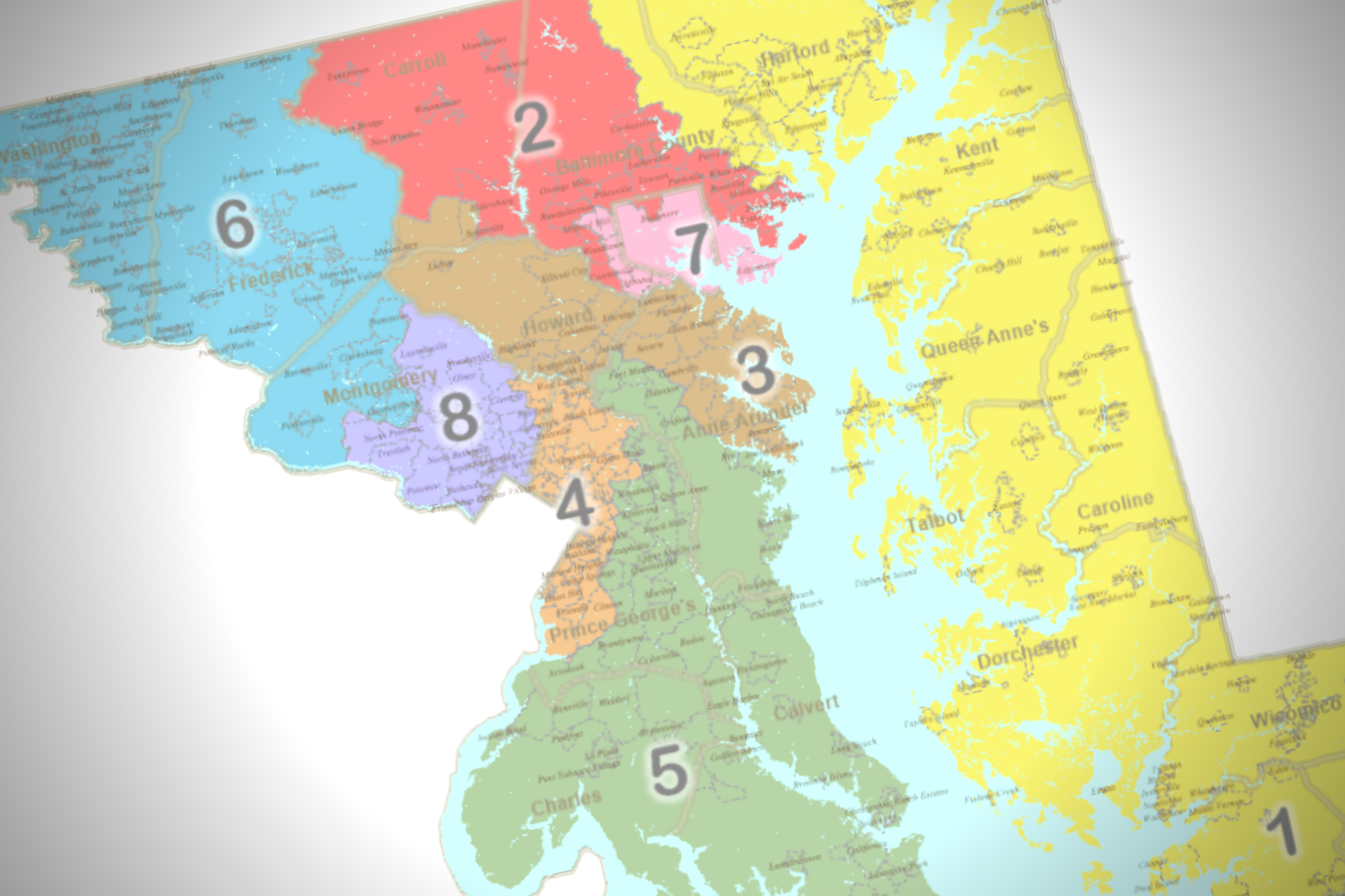
The new map generally includes significantly more compact districts than the previous proposal: The 1st District no longer crosses the Chesapeake Bay Bridge and would again be solidly Republican; the 6th District includes all of Frederick County and less of Montgomery County and would be more competitive in future elections; and Baltimore is largely contained within the 7th District, with the 2nd District extending far into Carroll County.
Sen. Michael Hough (R-Frederick) said that the map would still result in a 7-1 partisan breakdown in arguing that the map is still gerrymandered. Hough particularly took issue with the way the new 3rd District captures a small portion of southern Carroll County with Howard and Anne Arundel counties, along with the 2nd District’s move into Carroll County.
According to the political analysis outlet FiveThirtyEight, the redrawn 6th District is “highly competitive” with a very slight Republican lean of R+1. The 2nd District has a D+11 partisan lean, and the 3rd District has a D+14 lean.
At a press conference after the Senate approved the new map, Ferguson emphasized that the new map was drawn with a “different set of standards” — those traditionally applied to legislative districts — than the previous map. Judge Lynne A. Battaglia applied state constitutional requirements for compactness and respect for natural and political boundaries in legislative redistricting to congressional districts in throwing out the General Assembly’s initial map.
Update, 12 p.m.:
The Maryland Senate voted 29-13 to pass legislative leaders’ redrawn redistricting proposal Tuesday, with Democrats praising the map’s more compact districts and Republicans arguing that the map doesn’t respect county boundaries enough.
Sen. Christopher R. West (R-Baltimore County) said the map is “far superior” to the plan originally enacted by lawmakers during the December special session, but argued that the plan still included too many county crossings to comply with the state constitution. West particularly pointed to the 2nd and 7th districts’ crossings into Baltimore City from Baltimore County.
Senate President Pro Tem Melony G. Griffith (D-Prince George’s) said that, in addition to aiming to make districts more compact, the new map still tries to keep voters in their current districts when possible. Sen. Robert G. Cassilly (R-Harford) pushed back on residents being kept within the same district, and said it was “totally inappropriate” to do so.
Senate Minority Whip Justin D. Ready (R-Carroll) questioned the split of Carroll County between the 2nd and 3rd districts in the new map, noting that a small portion of southern Carroll County is included in the 3rd District with Howard and Anne Arundel counties.
Sen. Delores G. Kelley (D-Baltimore County) noted that there are still some different criteria between congressional and legislative districts. Unlike the plus or minus 5% population deviation allowed in legislative districts, for example, population variances need to be kept to an absolute minimum in congressional maps. Kelley said Marylanders aren’t spread out evenly across Maryland’s unusual geography.
Griffith noted that the legislature had a short time frame — five days including the weekend — to draw the new map, and said Department of Legislative Services staff members worked all weekend to create the bill language. If time permitted, Griffith said, each lawmaker could have come up with a different proposal for how the state’s congressional districts should look.
Senate Majority Leader Nancy J. King (D-Montgomery) said Senate President Bill Ferguson (D-Baltimore City) offered Department of Legislative Services staff members guidelines for how to draw a map in accordance with the court-ordered criteria.
Sen. Sarah K. Elfreth (D-Anne Arundel) praised the way her county is drawn in the new maps, with the north portion of her county being contained in the 2nd District and areas south of Annapolis up to Fort Meade included with Southern Maryland in the 5th District. She also noted that the county was split between four districts in the previous congressional map, which is limited to two under the new proposal.
Ferguson said he was “surprised” at the votes against the map, and said objections to the previous map had been effectively resolved by the new, more compact map.
— — — —
Original post, 10:15 a.m.
The Maryland Senate Reapportionment and Redistricting Committee voted along party lines Tuesday morning to approve a court-ordered redrawn congressional plan.
Senate President Bill Ferguson (D-Baltimore City) said at a Monday morning hearing that district compactness was the “driving factor” in creating the map along with population equality, and that no jurisdiction is part of more than three congressional districts. He added that the two districts drawn to comply with the federal Voting Rights Act in the previous map — the 4th and the 7th — still do so in the new proposal.
House Minority Leader Jason C. Buckel (R-Allegany) said the map appears to be more compact, but questioned whether legislative leaders had analyzed the partisan makeup of the new districts after Senior Judge Lynne Battaglia threw out last map as an “extreme partisan gerrymander.”
She ordered that the new map should apply principals of compactness and contiguity that the Maryland Constitution requires for legislative districts to congressional districts as well.
Ferguson noted that that section of the Constitution — Article III, Section 4 — addresses district shapes and population, but not political party.
He highlighted Battaglia’s new interpretation of the long-standing law.
“For 160 years, ‘legislative districts’ meant state legislative districts, and the interpretation applied because the word congressional was not included,” Ferguson said.
In her Friday opinion and order, Battaglia required lawmakers to draw up a new map by Wednesday. A court hearing for the new map is set for 9 a.m. this Friday.
Members of the public who testified at the Senate redistricting committee’s joint hearing with the House Rules and Executive Nominations Committee on Tuesday morning said there were still flaws in the more compact map.
Nicole Bennett, a District 5 resident, took issue with Democratic U.S. House Majority Leader Steny H. Hoyer’s longtime representation of southern Maryland, and argued that Southern Marylanders’ votes are diluted when combined with areas to the north.
“I don’t think it’s appropriate to give such a stretch to any congressperson,” Bennett said.
Antonio Pitocco, a Republican primary candidate looking to unseat U.S. Rep. John P. Sarbanes (D) in the 3rd District, argued that the redraw would have been avoided had lawmakers enacted the map drawn up by the Maryland Citizens Redistricting Commission, a panel convened by Gov. Lawrence J. Hogan Jr. (R). That panel, which included three Republicans, three Democrats and three unaffiliated voters, aimed to respect country boundaries in drafting their proposal.
Senate Minority Leader Bryan W. Simonaire (R-Anne Arundel) said that Republicans hadn’t been involved in the drawing of the new map.
“The Republican side was not involved at all,” Simonaire said. “And when you say General Assembly. It makes it sound like the Republicans were involved, we were informed, but not involved and I think that’s a flaw in the process.”
Bennett Leckrone
Reporter
Bennett Leckrone was a Report for America corps member at Maryland Matters through May 2022. He is a December 2019 graduate of the E.W. Scripps School of Journalism at Ohio University. Leckrone has interned at The Chronicle of Higher Education, The Columbus Dispatch, PennLive.com, The Dayton Daily News and The Troy Daily News.
Related Articles

Gov. Wes Moore signs more than 100 new bills into law a day after the 90-day 2024 legislative session ends. Former Gov. Robert Ehrlich (R) attends the event.

Bills aiding port workers and boosting the state’s struggling horse racing industry are among the last and most significant to pass on a Sine Day that was exceedingly busy — except during the solar eclipse.

House committee’s decision to amend a popular consumer protection bill puts its fate in doubt as Sine Die approaches.
 Creative Commons Attribution