Analysis: The Consequential Changes in General Assembly’s Redistricting Proposal
At first glance, the legislative redistricting proposal expected to advance in the General Assembly looks little changed from the current boundaries — but there are still notable shake-ups that will likely affect the 2022 elections.
The map put forward by the Legislative Redistricting Advisory Commission, convened by Senate President Bill Ferguson (D-Baltimore City) and House Speaker Adrienne A. Jones (D-Baltimore County), will guide the decennial redistricting debate, just as the panel’s congressional proposal carried sway during a special legislative session last month.
That map — and one created by a commission appointed by Gov. Lawrence J. Hogan Jr. (R) — are up for a public hearing and possible committee vote at 3 p.m. Tuesday.
Here are some of the most consequential changes in Legislative Redistricting Advisory Commission’s map:
District 11 in Baltimore County now includes a single-member majority Black district around Owings Mills. Jones, a member of the commission, said at a Daily Record event last week that the single-member district was drawn to comply with the federal Voting Rights Act, based on guidance from the Attorney General’s office. That could impact the district’s three Democratic House incumbents, Dels. Lisa M. Belcastro, Jon S. Cardin and Dana M. Stein, who are white.
District 9 in Howard County will include a portion of northern Montgomery County around Damascus as opposed to part of southern Carroll County, a move that could shore up Sen. Katie Fry Hester (D-Howard) for re-election. That district is currently split into a two-member delegate District, 9A, represented by Republicans Del. Trent M. Kittleman and Reid J. Novotny in the northern and western portions of the county, and a single-member district around Ellicott City, 9B, represented by Democratic Del. Courtney Watson.
Novotny on Tuesday announced a bid to unseat Hester, charging that Democrats “gerrymandered the district I currently represent to keep the incumbent Democrat senator.”
Combining parts of Montgomery and Howard counties in state legislative maps isn’t unprecedented. Former state Sen. Edward J. Kasemeyer (D) represented a district as a House member that included portions of both counties until it was redrawn in 2002, although that district included the Olney area rather than northern Montgomery County communities.
While districts crossing county lines are at times necessary to account for population differences, Kasemeyer said in an interview said those districts create “a lot more work for a representative in that you have to be knowledgeable with the issues of two jurisdictions.”
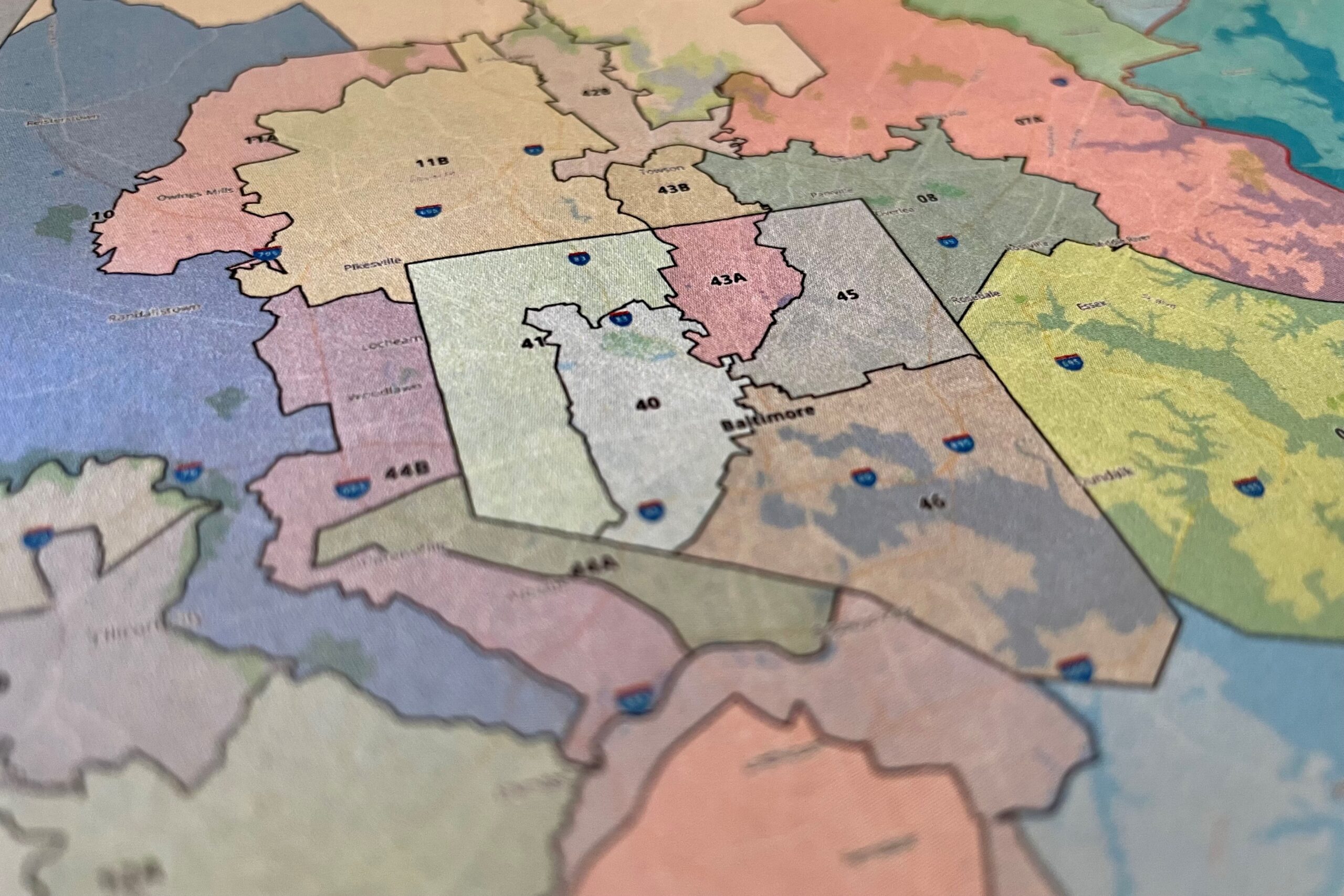
Baltimore City lost population in the last decade, and that’s reflected in the proposed Legislative Redistricting Advisory Commission map. Currently, the city contains five whole senatorial districts and a portion of another, with the single-member House District 44A including a sliver of west-central Baltimore.
In the proposed Legislative Redistricting Advisory Commission map, Baltimore contains just four full senate districts, with District 43 still contained largely in the north-central part of the city and now including a single-member delegate District, 43B, around Towson. The proposed District 43B around Towson is nearly identical to the current District 42A, currently represented by Del. Catherine M. Forbes (D-Baltimore County).
At a public hearing in December, Baltimore resident and District 43 candidate Reginald Benbow said he was worried that adding Towson to the existing district would dilute the voice of historically redlined communities in the city.
“You just have the potential of a more affluent community in Towson mixed in with some of the affluent communities already from the 43rd district that could overwhelm the interest of some of the neighborhoods that have historically been marginalized,” Benbow said.
Anne Arundel County’s District 33, currently a competitive district represented by Republican Sen. Edward R. Reilly, would be divided into three House subdistricts and shifted southward to no longer encompass all of Severna Park — becoming more favorable to Democrats. The district as currently drawn has one Democratic delegate and two Republicans, but that could change — and Democrats may target Reilly in the general election, if he gets through his primary with free-spending Stacie MacDonald, a conservative activist.
The map in general helps vulnerable Democrats and could also add a few Democratic state senators and state delegates, said Richard DeShay Elliott, a Prince George’s County-based Democratic strategist and 24th District candidate for state delegate. Elliott thinks District 9A in particular could be a pick-up opportunity for Democrats.
Shake-ups in a few Republican districts aren’t the only potential changes the map has in store — there could also be a reordering in some Democratic districts as well.
If the maps proposed by the Legislative Redistricting Advisory Commission are approved, Elliott said he expects the Democratic primary in District 23 in Prince George’s County to be the “marquee race” in the jurisdiction this year. Sen. Ronald L. Watson Jr. (D) was appointed to the seat last year after Sen. Douglas J.J. Peters’ resigned to take a seat on the University of System of Maryland Board of Regents.
Prince George’s County Central Committee Chair Cheryl Summers Landis was appointed to represent District 23B, although political observers have said they expect her to serve only on a temporary basis.
Observers also believe the uniting of the district creates uncertainty for Del. Geraldine Valentino-Smith, who currently represents the single-member District 23A. Watson’s political ticket is slated to include incumbent District 23B Del. Marvin E. Holmes Jr. (D), Jocelyn I. Collins, the state government relations director for the American Cancer Society Cancer Action Network, and Kym Taylor, a former aide to Sen. Paul G. Pinsky (D-Prince George’s).
“It is in many ways an open Senate seat, along with two open delegate seats,” Elliott said.
Elliott added that Democrats could have gone further to pick up even more seats if they wanted to. Creating a Senate district encompassing Salisbury and Cambridge could add a Democratic senator to the lower Eastern Shore, Elliott said. House Speaker Pro Tem Sheree Sample-Hughes is currently the lone Democrat from the Eastern Shore, representing District 37A, which includes part of Salisbury.
Why this is different than congressional redistricting
Legislative redistricting tends to be an even more complex process compared to its congressional counterpart. Lawmakers not only have to draw more district lines, but are also beholden to state rules requiring legislative districts to be geographically compact and respect political boundaries.
And the map is subject to the competing interests of 141 delegates and 47 senators, the majority of whom are seeking another term in the General Assembly.
Lawmakers need to consider just two primary factors in congressional redistricting: Compliance with the federal Voting Rights Act and keeping population deviation to an absolute minimum. The Voting Rights Act is still at the forefront in legislative redistricting, but respect for county and municipal boundaries is also mandated by the state constitution.
Adding to the complexity, state delegate districts in Maryland are required to be nested within state Senate districts. The state constitution allows House districts to be configured in three different ways: Entirely multi-member, with three delegates elected on an at-large basis; entirely single-member, meaning the senatorial district is subdivided into three sub-districts for delegates; or a mix of single- and multi-member districts.
Lawmakers also have more flexibility over population variances when it comes to legislative districts. Maryland’s constitution allows up to a plus or minus 5% deviation in legislative districts’ population. The target populations in the new maps are 131,391 for Senate districts and 43,797 for single-member delegate districts.
The plus or minus 5% margin means that, theoretically, senatorial districts could be overpopulated or underpopulated by as many as 6,569 residents with a maximum gulf between the state’s most- and least-populated districts up to 10%, or more than 13,000 people.
At a public hearing last month, Karl Aro, chair of the legislative redistricting panel and a former head of the nonpartisan Department of Legislative Services, said the map keeps population variances to plus or minus 4%, which is smaller than any legislative maps he worked on during his tenure at the Department of Legislative Services.
“In my previous four rounds of redistricting, this is the smallest maximum deviation that we’ve ever achieved,” he said.
Some Republican lawmakers, including Senate Minority Leader Bryan W. Simonaire (R-Anne Arundel) have raised concerns that Republican districts in Western Maryland and the Eastern Shore tend to have a higher population packed into one district, while Democratic districts around Baltimore tend to have lower populations.
All Senate districts on the Eastern Shore are overpopulated, although the single-member districts 37A and 38B, drawn to comply with the Voting Rights Act and boost representation of Black voters, have only slight population variances.
Western Maryland remains contained in District 1. District 1A, the furthest western subdistrict, has a population deviation of roughly -2.1%. District 1B around Cumberland has a positive deviation of 2.1%. District 1C, which begins just west of Hagerstown, has a positive population deviation of 2.7%.
In Baltimore City, which lost population over the past decade, all districts are underpopulated. The full senatorial districts contained within the city — districts 40, 41, 45 and 46 — all have a population deviation of roughly -4%. District 43A has a population deviation of -3%, and District 43B in Baltimore County has a deviation of -3.6%.
But population deviation in the proposed Legislative Redistricting Advisory Commission map doesn’t always correlate with party affiliation: In Charles and Prince George’s counties, Democratic strongholds which grew over the past decade, districts tend to be overpopulated. District 28, contained entirely within Charles County, has 5,112 more residents than the target, a 3.9% positive deviation. Fast-growing Prince George’s County also has districts with high positive population deviation: Senatorial districts 22, 23, 24, 25, 26 and 47 all have a positive population deviation of more than 3%.
How the debate will play out
Maryland’s governor is constitutionally required to kickstart the legislative redistricting process by submitting a map to the General Assembly — but the map proposed by Gov. Lawrence J. Hogan Jr. (R) isn’t likely to live long.
Hogan’s proposal was drawn up by the Maryland Citizens Redistricting Commission, a multi-partisan panel he created last year. That panel’s proposal received high marks for partisan fairness from the Princeton Gerrymandering Project. But like its congressional counterpart, is unlikely to advance out of committee.
Democratic lawmakers easily passed their congressional proposal during a special session in December. They also quickly overrode a veto from Hogan, who said he would oppose any map different from the Citizens Redistricting Commission plan. A similar conflict will likely play out in the coming weeks, though Hogan can’t veto the legislative map passed by lawmakers; the state constitution requires the governor to submit a legislative redistricting plan to the General Assembly, which becomes law if legislators don’t make changes within 45 days. .
Lawmakers will also decide whether to use single- or multi-member House districts. Republicans favored a shift to single-member districts, which political observers believe would result in a few Republican pickups in the House of Delegates. At hearings conducted by the redistricting panels, proponents argued that the smaller size of single-member districts makes it easier for political newcomers to challenge incumbents and make politicians more accountable to communities, while others argued that multi-member districts offer constituents access to lawmakers with different areas of expertise and make it easier for women and people of color to get elected.
Democratic legislative leaders have said they want to keep as many people in their existing districts as possible in both congressional and state legislative maps. After the Legislative Redistricting Advisory Commission approved the map along party lines earlier this month, Ferguson hailed the proposal because “the overwhelming majority of Marylanders are in their existing districts.”
Del. Kathy Szeliga (R-Baltimore and Harford counties) said in an interview that the Citizens Redistricting Commission opted to start from scratch rather than work with existing maps, and called the existing districts “shamefully gerrymandered.”
“I think the continuance of perpetuating these gerrymandered multi-member districts… is a real disservice to the citizens of the state of Maryland,” Szeliga said.
Szeliga, one of the plaintiffs in a lawsuit over the state’s congressional map, said she expects additional legal action if the Legislative Redistricting Advisory Commission’s legislative maps are enacted.
If challenged, the Maryland Court of Appeals — where a majority of judges have been appointed by Hogan during his eight-year tenure — would consider the case.
“If [lawmakers] pass the worst gerrymandered maps in America, there’s no question that lawsuits will be filed and hopefully [the maps] will be overturned,” Hogan said during a pre-session forum with The Daily Record last week. “And the judges can install the [Citizens Redistricting Commission] maps, or they can create their own.”
Ferguson said at the Daily Record event that he expects the map to hold up in court.
“Talking points are talking points,” Ferguson said, when asked about criticism from the governor in particular. “This is a fair map. It’s a fair map that reflects the changes in demographics, the shifts in population, it account accounts for where people have moved … and I feel confident that it will withstand legal scrutiny.”
Bennett Leckrone
Reporter
Bennett Leckrone was a Report for America corps member at Maryland Matters through May 2022. He is a December 2019 graduate of the E.W. Scripps School of Journalism at Ohio University. Leckrone has interned at The Chronicle of Higher Education, The Columbus Dispatch, PennLive.com, The Dayton Daily News and The Troy Daily News.
Related Articles
Two powerful Black officeholders from Prince George’s turn against their county executive, while The Washington Post editorial board takes sides in the primary.

‘The liquor store was open during COVID, but not the reentry programs,’ an advocate notes.
Leaders highlight the GOP Senate candidate’s history of vetoing legislation on health care, housing bills during his term as governor.
 Creative Commons Attribution