At Hearing, Marylanders Urge Redistricting Commission To Draw More Competitive 1st Congressional District

Marylanders said the state’s solidly Republican 1st Congressional District should be redrawn to be more competitive at a Monday evening Legislative Redistricting Advisory Commission hearing, citing U.S. Rep. Andrew P. Harris’ vote earlier this year against certifying the 2020 presidential election results.
Harris, the state’s lone Republican in Congress, was among a majority of U.S. House Republicans who objected to certifying the 2020 presidential election results after the insurrection at the U.S. Capitol on Jan. 6. People who testified at Monday’s meeting cited that vote, alongside Harris’ vote against awarding Congressional Gold Medals to police officers who protected the Capitol that day, as reasons to draw a more competitive 1st District.
The Legislative Redistricting Advisory Commission (LRAC) released four “concept” congressional maps last week. While two of those maps would likely maintain Democrats’ current 7-1 advantage in the state, two would combine the Eastern Shore with portions of Anne Arundel County to create a more competitive 1st District.
“The existing congressional map has empowered an extremist to represent us with little fear of retribution for any of his actions or comments,” Queen Anne’s County resident Peter Behringer said at a statewide virtual LRAC hearing Monday.
Behringer said lawmakers should draw up a 1st District that is “competitive and balanced” and empowers people of color.
Those who testified overwhelmingly supported Plan 3, boundaries proposed by the commission that include a large portion of Anne Arundel County with the Eastern Shore and is the closest to an 8-0 Democratic map. That plan would include a 1st District that would favor Democrats 55%-45%, according to an analysis by the Princeton Gerrymandering Project.
Plan 2, which includes a smaller portion of Anne Arundel County with the Eastern Shore, would favor Democrats 51% to 49%, according to the analysts at Princeton. The Princeton Gerrymandering Project gave all four maps a failing grade after researchers rated them based on “partisan fairness,” “competitiveness” and “geographic features.”
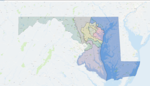
The first of four congressional concept maps released by the Legislative Redistricting Advisory Commission Tuesday, Nov. 9.
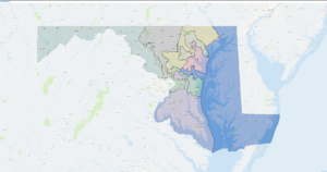
The second of four congressional concept maps released by the Legislative Redistricting Advisory Commission on Tuesday, Nov. 9.
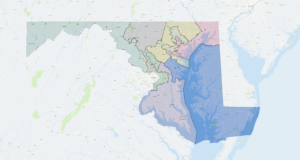
The third of four congressional concept maps released by the Legislative Redistricting Advisory Commission on Tuesday, Nov. 9.

The fourth and final congressional concept map released by the Legislative Redistricting Advisory Commission on Tuesday, Nov. 9.
Harris has handily won re-election bids in the 1st District since he ousted Democratic Rep. Frank Kratovil won by a wide margin in the 2010 election, and garnered 63.4% of the vote against challenger Mia Mason’s 36.4% in the 2020 election. His current Democratic challengers include former state Del. Heather R. Mizeur and foreign policy strategist R. David Harden.
The 1st District currently includes the entire Eastern Shore before looping north to include parts of Harford, Baltimore and Carroll counties.
“He can lean extremely far to the right since the current map stacks Republicans together in District 1,” Felicia Martin, a Harford County resident, said. “Districts should be drawn so that representatives can contemplate a spectrum of issues and be willing to work with both parties.”
Judy Wixted, an Eastern Shore resident, said Plan 3 is “somewhat acceptable,” but added that she doesn’t think the plan goes far enough to challenge Harris.
“This district, as it was drawn ten years ago, packed MD-1 in such a way that only the most radical Republican could win a primary,” she said.
Mason likewise urged lawmakers to draw a more competitive 1st District at the meeting, and also noted the vast geographic size of the district as it’s currently drawn, comparing it to “two Delawares.”
Some who testified at the meeting said it makes sense to combine the Eastern Shore with Anne Arundel County, since the regions are connected by the Chesapeake Bay Bridge. Marnette Finn, an Anne Arundel County resident, said the Eastern Shore is linked “culturally and economically” with Anne Arundel County because of the bridge. She said it makes more sense to connect the Eastern Shore with the rest of Maryland at the bridge rather than by going north through Harford County.
“Both regions have the same economic and environmental interest in protecting the Bay,” Finn said.
Paul Berman noted that Gov. Lawrence J. Hogan Jr. (R) has said he wants the planned third span of the Chesapeake Bay Bridge to be built at the current site.
“Governor Hogan’s insistence on expanding the connection between the Eastern Shore and Anne Arundel County offers clear confirmation of this commission’s [Plan 3]. Linking the Eastern Shore with Annapolis and a large portion of Anne Arundel County would provide the best configuration for Maryland’s 1st Congressional District,” Berman said.
The congressional map proposed by Hogan’s Maryland Citizens Redistricting Commission (MCRC) keeps the Eastern Shore linked with parts of northern Maryland. That map received high marks from the Princeton Gerrymandering Project for partisan fairness, and Hogan has said he will oppose any maps from the General Assembly that differ from the MCRC’s proposal.
While Hogan could veto congressional maps, Democrats hold a veto-proof majority in both the House of Delegates and the State Senate and have complete control over the redistricting process in Maryland. Lawmakers are set to tackle congressional redistricting at a special session beginning Dec. 6.
Maryland’s current congressional district map was challenged as an illegal partisan gerrymander in federal court and considered by the Supreme Court twice, with justices ultimately decided not to set a standard for what constitutes extreme gerrymandering.
Bennett Leckrone
Reporter
Bennett Leckrone was a Report for America corps member at Maryland Matters through May 2022. He is a December 2019 graduate of the E.W. Scripps School of Journalism at Ohio University. Leckrone has interned at The Chronicle of Higher Education, The Columbus Dispatch, PennLive.com, The Dayton Daily News and The Troy Daily News.
Related Articles

All 10 members of the Maryland congressional delegation have sponsored the measure, including the lone Republican, U.S. Rep. Andy Harris.

The U.S. Coast Guard is leading efforts to clear debris from the site to reopen operations at the busy Port of Baltimore.

Maryland’s congressional delegation votes for the spending package, with the exception of the lone Republican, U.S. Rep. Andy Harris.
 Creative Commons Attribution