Anne Arundel Residents Urge Legislative Redistricting Commission to Keep County Whole In Congressional Maps
Anne Arundel County residents urged members of the Legislative Redistricting Advisory Commission to keep their county whole in congressional maps during a Thursday evening public hearing.
However, some Anne Arundel residents at the meeting said the commission should include portions of the county in a district with the Eastern Shore.
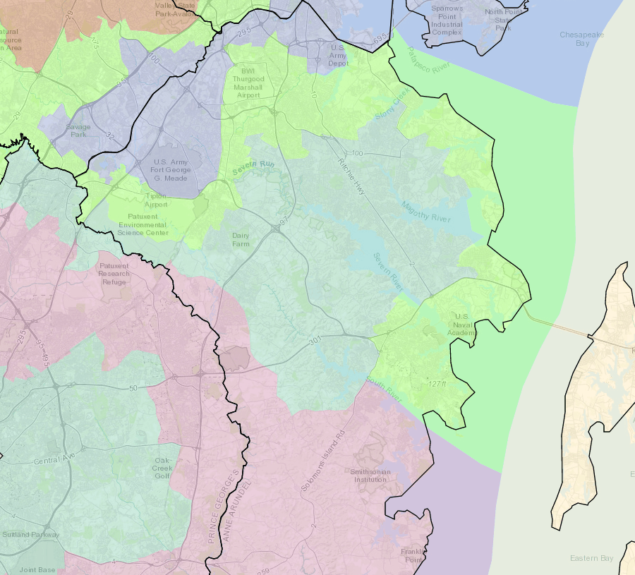
Abby Root of the League of Women Voters of Anne Arundel County said the commission shouldn’t start with current congressional maps when creating new districts, and noted that the county is currently split between four congressional districts.
The 5th District captures the southern portion of the county; the 4th District snakes in from Prince George’s County to grab central portions of Anne Arundel; the 3rd District starts just south of Annapolis and crawls up the western shore of the Chesapeake Bay before stretching farther west; and the 2nd District includes part of northern Anne Arundel.
“County residents need dedicated representation, not more representation,” Root said during the hearing at Anne Arundel Community College in Arnold.
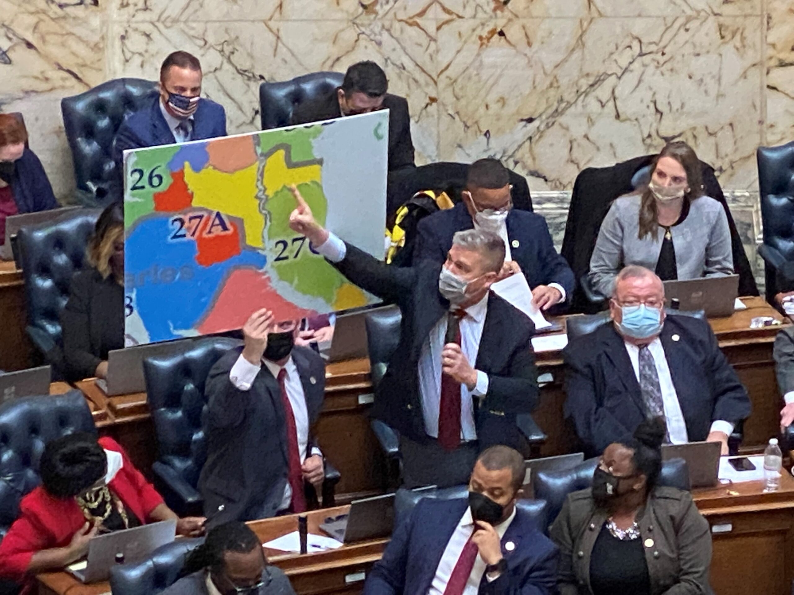
Paul Sundell called gerrymandering “one of the worst acts that a politician can do.” He said Anne Arundel County is among the most gerrymandered jurisdictions in Maryland and the United States, and noted that none of Maryland’s current congressional representatives live in Anne Arundel.
Sundell said counties should be kept whole as much as possible in the state’s next set of maps.
Shawn Smith likewise said the county shouldn’t be carved up in Maryland’s next congressional maps. He also noted that lawmakers have more flexibility over the size of state legislative districts, but said lawmakers should look to make those districts as close in population as possible.
The Legislative Redistricting Advisory Commission was convened by House Speaker Adrienne A. Jones (D-Baltimore County) and Senate President Bill Ferguson (D-Baltimore City) to conduct public hearings and draw up congressional and legislative maps.
This summer, the separate Maryland Citizens Redistricting Commission, which Gov. Lawrence J. Hogan Jr. (R) created via executive order, heard similar testimony from Anne Arundel County residents during their first round of public hearings. After those hearings that commission split the county between two congressional districts in their proposed maps, including most of the county in a district with Howard County and drawing the northern quarter of the county into a district with Baltimore City.
Aaron Marcus, who lives in northern Anne Arundel, told the Legislative Redistricting Advisory Commission members Thursday that he opposes northern areas of the county being drawn into a district with Baltimore City.
Other Anne Arundel residents wanted to see portions of their county joined with the Eastern Shore via a district that would cross the Chesapeake Bay.
Westbrook Murphy said commission members should look at crossing the bay at the Chesapeake Bay Bridge to include parts of Anne Arundel County with the Eastern Shore in a district. He said central Eastern Shore residents have more in common with people from Anne Arundel County than with residents of Carroll, Harford and Baltimore counties where the 1st District currently extends.
Crossing the bay in congressional maps has been done in the past. From the early 1970s to the early 1990s, the 1st Congressional District included portions of southern Maryland and the entire Eastern Shore of Maryland.
Mildred Bowers also asked that portions of Anne Arundel County be joined with the Eastern Shore.
“We have a vested interest in the Chesapeake Bay bridges and the traffic issues that are felt on both sides of the Bay,” Bowers said.
Michael Lore, chief of staff to Sen. Susan C. Lee (D-Montgomery County), told panelists that he also thinks parts of eastern Anne Arundel County, particularly communities on the Bay, should be joined with the Eastern Shore. Lore said he was testifying on behalf of himself.
Lore also said the commission should keep multi-member delegate districts in their next set of maps.
The General Assembly, where Democrats hold a veto-proof majority in both the House of Delegates and the Senate, will have the final say over the state’s next set of maps.
The governor can veto only congressional maps, although lawmakers easily overrode Hogan’s vetoes on such measures as police and education reform during the 2021 legislative session.
Although the governor can’t veto the General Assembly’s legislative maps, his proposed maps would become law if the General Assembly doesn’t pass a redistricting plan within the first half of the 2022 legislative session.
Bennett Leckrone
Reporter
Bennett Leckrone was a Report for America corps member at Maryland Matters through May 2022. He is a December 2019 graduate of the E.W. Scripps School of Journalism at Ohio University. Leckrone has interned at The Chronicle of Higher Education, The Columbus Dispatch, PennLive.com, The Dayton Daily News and The Troy Daily News.
Related Articles
A new report issued by a coalition that includes Common Cause, calls on the state to create an independent commission to draw maps after the 2030 Census.

Gov. Lawrence J. Hogan Jr. (R) talked economic recovery and took shots at the legislature for their progressive economic and criminal justice policies at…

Marylanders urged members of the General Assembly’s Legislative Redistricting Advisory Commission at a Tuesday hearing to make draft maps available for public comment before…
 Creative Commons Attribution