Tropical Storm Isaias Expected to Bring Heavy Rain, Flood Threat to Region
Chances of rain will increase early this week as Tropical Storm Isaias moves closer to the area, with a possibility for torrential tropical downpours and flooding in the D.C. region.
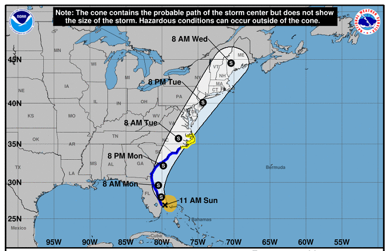
Even though the storm weakened from a hurricane on Saturday, Isaias — currently near Florida — is forecast to parallel the U.S. East Coast, according to NBC Washington meteorologist Lauryn Ricketts, a path which would bring tropical storm conditions to the region from Monday night through Tuesday.
The storm — pronounced ees-ah-EE-ahs — had already prompted Virginia Gov. Ralph Northam to declare a state of emergency for the potential of heavy rain and gusty winds from coastal Virginia through Maryland’s Eastern Shore.
While Isaias’ path is still uncertain, it appears increasingly likely that eastern Virginia could be impacted and must prepare for the possibility of flooding, high winds and potential storm surge, a news release from Northam’s office said.
The National Hurricane Center’s official forecast track as of Sunday morning had Isaias making landfall as a strong tropical storm in the Carolinas late Monday, before racing northward over the Chesapeake Bay through New Jersey with sustained winds between 45 and 60 mph.
Parts of the Washington, D.C metropolitan area could see rain totals of up to 6 inches, enough to pose a significant flash flood threat.
“Confidence for the heavy rainfall is highest along and east of the Blue Ridge Mountains, but the area may shift depending on the exact track of Isaias,” the National Weather Service’s D.C. regional office said in its Sunday forecast discussion.
“The best chance for tropical storm force winds will be near and east of the center of Isaias, but the heavy rainfall may extend well north and west from the track of Isaias.”
As part of Maryland Matters’ content sharing agreement with WTOP, we feature this article from Matt Small. Click here for the WTOP News website.
Maryland Matters is a proud partner with WTOP News, which delivers the latest local news, traffic and weather information to the Washington, D.C., region. Click here for the WTOP News website.
Related Articles

A bill that got a boost of momentum right before the end of the 2024 legislative session tries to keep lower- priced prescription drugs accessible to lower income Marylanders.
Funding programs emerge to help Maryland reach its goal of putting 5 million native trees on public and private lands by 2031.
Young conservatives who favor acting to combat climate change may seek guidance from the former governor’s environmental record.
 Creative Commons Attribution