Hogan Panel Proposes New Congressional Map — Which Dems Are Likely to Ignore
The state commission tasked with drawing new congressional boundaries for the 2020 election adopted a map on Friday.
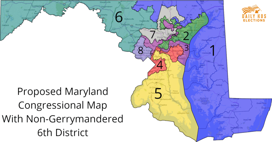
While Maryland’s current congressional map is wildly contorted and in the eyes of many begs for a wholesale redrawing, Maryland’s Emergency Commission on 6th District Gerrymandering, created by Gov. Lawrence J. Hogan Jr. (R), had a narrow charge: to fix the problems identified by a federal court last year.
During their work-session on Friday, members of the panel decided to focus primarily on the line between the 8th District, currently represented by Rep. Jamie Raskin (D), and the 6th, the seat now held by freshman Rep. David J. Trone (D). Their plan will be subject to two public hearings and will be used as the basis for legislation that Hogan plans to introduce in the final days of the General Assembly session.
The map the commission chose was created by Stephen Wolf, staff writer at Daily Kos. His twitter profile (@PoliticsWolf) lists his interests as “voting rights, redistricting, maps and poli sci.”
The commission’s proposed 2020 map, which was adopted unanimously, makes the following changes:
— It unites Frederick County into the state’s western-most district, the 6th.
— It moves central and southern Carroll County from the 8th Congressional District to the 6th District. (The northern and eastern portion of Carroll remains in the 1st District, currently represented by the state’s lone Republican congressman, Andrew P. Harris.)
— Portions of central Montgomery County move from the 6th District to the 8th.
The northwestern tier of Montgomery County remains in the 6th District, because without those voters the 6th wouldn’t have the 721,512 residents required by law.
As drafted, Germantown and Darnestown remain in the 6th; Gaithersburg, Norh Potomac, Travilah and Laytonsville end up in the 8th.
“Montgomery County would be divided so that areas that are more part of the D.C. suburbs would be united in District 8,” said commission co-chair Walter Olson.
“And the areas that we approved putting in District 6 are areas that have more in common with the rural communities, with the agricultural reserve.”
“Above all we were trying to follow the marching orders that the court gave in the unanimous opinion finding [that the current 6th District is] unconstitutional,” Olson added.
A group of Republicans from Western Maryland challenged the state’s congressional map nearly a decade ago on the grounds that their rights of association were violated when the Democrats who control the General Assembly redrew the 6th District to make it more difficult for then-Rep. Roscoe G. Bartlett (R) to win re-election. He subsequently lost the 2012 election to John K. Delaney (D).
Their challenge made it to the Supreme Court last spring, but the justices sent the case back to the federal appeals court, which last year issued a unanimous order to redraw the 6th District. When Maryland Attorney General Brian E. Frosh (D) appealed that ruling, the Supreme Court agreed to schedule another hearing on the map, which will be held on March 26. Frosh and Maryland Democrats are hoping the Supreme Court will set guidelines for what constitutes excessive partisanship in congressional and legislative mapmaking.
In the meantime, two public hearings will be held to give voters the opportunity to comment on the map the commission chose. The first hearing will be held on Tuesday, March 12, at 7 p.m. in Germantown. The second will be held on Wednesday, March 20, at 7 p.m. in Hagerstown. The locations for those hearings have yet to be determined.
The commission will meet again on Friday, March 22, to consider the public’s comments. Commissioners will then submit their proposed boundaries to Hogan, who will introduce the map in legislation and hopes the General Assembly will adopt it before adjourning on April 8.
It is considered highly unlikely that the legislature will consider a commission-produced map while redistricting is pending before the Supreme Court. Should the high court order the state to produce a new map for the 2020 election, the General Assembly would have to return to Annapolis for a special session later this year.
The legislature and governor are slated to redraw the state’s entire congressional map in 2021, following next year’s federal Census. That plan would be in place for a decade.
The legislature is considering a number of redistricting-related bills this session, including a Hogan-backed measure that would take line-drawing power from the Assembly and give it to an independent commission.
A number of states have created non-partisan panels in recent years in an attempt to reduce political gerrymandering. But Hogan’s efforts to adopt a similar system in Maryland have run aground in the Democratic-controlled legislature.
Hogan and other critics routinely denounce Maryland’s map as one of the most gerrymandered in history. Several of the state’s congressional districts are wildly misshapen, the result of software-aided changes Democrats made in 2011 to maximize their chances of winning House races, just as Republicans have done in states like Texas that they control.
It is unclear what the political tilt of the new 6th District (if it is adopted) would be. Wolf, who drew the map, calculated that the 6th would shift from having voted 55 percent for Hillary Clinton in the 2016 White House election to 40 percent for President Trump under the existing map to instead having gone 53 percent to 42 percent for Trump under Wolf’s proposal. The 8th District would move from a 65-31 Clinton district to a 78-18 Clinton district.
Democrats currently hold a 7-1 advantage in the state’s congressional delegation.
Political operatives from the two parties will no doubt start crunching voter registration numbers from the proposed district to determine the new lay of the land. But the commission that is proposing the lines is not going to do so.
“We are specifically forbidden to spend time making that a part of our calculus,” Olson said. “Someone else will know where the chips fall. Our job was to throw them up in the air.”
Bruce DePuyt
Reporter
Bruce DePuyt is a contributor to Maryland Matters, where he was a full-time reporter until December 2022. Previously, DePuyt spent nearly three decades on local television, including 14 years as producer and host of “NewsTalk” on NewsChannel 8 in the Washington, D.C., region. He was a reporter and anchor on “News 21” in Montgomery, where he also served as producer and host of “21 This Week.” He then became a reporter and anchor at NBC affiliate WVIR in Charlottesville, Va. He appears occasionally on WTOP (103.5 FM), WAMU (88.5 FM) and MPT.
Related Articles
Governor to headline an upcoming fundraiser for the Prince George’s County executive’s U.S. Senate campaign.
Maryland’s Harris votes against all the foreign aid measures; Raskin joins 36 progressive Democrats voting against aid to Israel bill.
The leading Democratic candidates for U.S. Senate tout experience, statewide support and electability in the Fox45 studios in Baltimore.
 Creative Commons Attribution